Day Five of my jollies didn't feature any walking as the spring rain pounded down and my four mile round trip from Tebay to Blease Fell, on the edge of the Howgills and above the Lune Gorge, was substituted with taking in the scenic parts of the M6 and A6, culture at The Museum of Lakeland Life, the Abbot Hall Art Gallery and the Parish Church in Kendal, and shopping at K Village and Tebay Services. So Friday is upon us and it feels like we're running out of holiday, and having absorbed most of the guides to short walks in the vicinity, I had better pick a route and get my boots primed for another early start...
Spring Jollies: Day Six
Lammerside Castle & Wharton Hall. 6.6 miles
plus Great Asby Scar. 3.6 miles
 |
| The Northern Viaduct Trail |
The early start is delayed as I wait for the day to brighten up, and leave Manor Lodge at 8.45am when it becomes clear that the day is going to be gloomy for a while. So onward up High Street to join Nateby Road, getting caught up in the school traffic for the local primary school, before heading down the familiar path to cross the Eden below Stenkrith Park and then follow the bridleway to Nateby. Cross the Viaduct trail and then it's into the unknown for a while, trying to find a nice bit of Brockram for my holiday stones collection but finding that most of the stone on the path is not indigenous to the area. Watergate Lane takes me round the back of Nateby to emerge at its east end, and then its up the path to join the Mallerstang road. It's definitely taken a wet turn along here and the meadows might look pretty with the daisies and buttercups, but the going is soft. The road takes us by Thringill farm, and then its down to the riverside again, by a fishing lake that's not on the map to cross the Eden again by Mire Close Bridge, as unattractive construction as you could wish for. A concrete farm track tempts as the way to go until I realise I'm on the wrong side of a stream and find that the correct path leads through a meadow where the long grass renders the path invisible, it's no fun to walk as the grass drags on you, saturates your trousers and waterlogs my boots. Squelch up hill towards Lammerside Castle as a flock of ducks takes off spectacularly and the only patch of sunshine to be seen is illuminating Mallerstang Edge.
 |
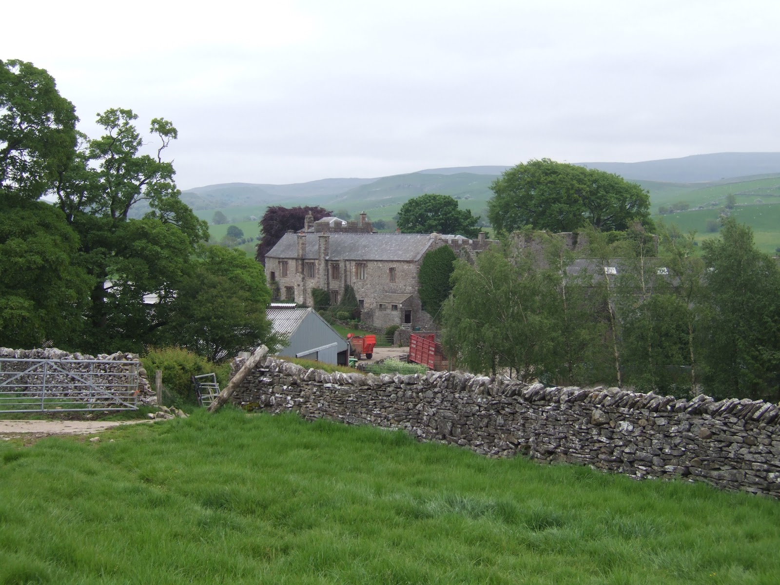
| Lammerside Castle |
Lammerside Castle may look modest, but it was once part of a much larger structure, built as a Peel in the 12th century and enlarged in the 14th, all that remains is the central tower to first floor height with earthworks indicating other surrounding buildings. It failed to endure as seat of significance for the Warcop family as they had to contend with the much more powerful Cliffords and Whartons at Pendragon Castle and Wharton Hall for dominance in Mallerstang. I pause to tell you this tale of medieval power play as my path is blocked by cows who do not want me to enter their field, and after shooing them away from the gate, I am not given much of a chance to explore or photograph as one takes it upon herself to follow me at just quicker than walking pace and I go on at the hurry-up for fear of be charged and trampled. Only feel safe and get the heart-rate down once I've taken a dive over the gate out of the field, and said cow stares me down until I'm gone. Maybe they were protecting their calves, or perhaps it's just that Friesians are stupid and aggressive creatures by nature.
 |
| The Settle & Carlisle Line |
Take the path by Croop House farm, and look for a return point as I don't want to venture further into Mallerstang, so take the bridleway up towards Tommy Road only to find a pair of horses who have gotten out of their field and into the lane. I figure that today must be the day that I am scheduled to die under the hooves of a spooked animal, so progress with trepidation, fortunately, horses are more likely to run away when afraid so I let them panic their way out of the way before passing under the S&C line. Follow the path back north, along a broad avenue of dry stone walls, which leads to an excellent spot by the railway for a bit of photography, if there were any trains passing, and then on to Wharton Lane. Passing Bullgill farm, I note that most of the farms in the area have built date in the 1660s, so it looks like post-Restoration was the time that this part of the world thrived. Rejoin the bridleway down to Wharton Hall, and feel wary of the cattle that make bad tempered sounds, and finally spot one of the more impressive ancient earthworks which can be found in this area.
 |
| Wharton Hall |
Wharton Hall is an impressive fortified tower house, built in the 15th and 16th centuries by the de Wharton family, and it comes complete with gatehouse and courtyard and looks like the product of an ambitious family in the late medieval period. The hall is still an active farm, and thus cannot be accessed, and it unfortunately has too many contemporary farm buildings around it, rendering it hard to photograph, but worth a look and worth seeking out aerial photographs for a proper look. Feels like I've not got a lot of morning left so hit the track back toward Halfpenny House and don't venture to Stenkrith Park again as my boots are too we for more field walking, instead venture through Jubilee Park, laid out a decade ago as a pleasingly wild little forest park on the edge of town, with a bandstand that offers an excellent perspective on Wild Boar Fell. Then down into the town once more, to desire a nice town house out in the countryside, and to love the 1930 motor-garage on the corner of Rowgate. Back to take a necessary shower and to find my parent too have ventured out to walk to, to Hartley and back, and so we've all earned our lunch.
~~~
 |
| Great Asby Scar, from Sayle Lane |
In the afternoon, we drive out to find a place to take a look at Great Asby Scar, the vast area of limestone pavement that covers the upland above the infant River Lune, which is the natural feature that any visitor to this part of the world should see. Naturally, the roads keep well away from it, so the nearest decent access point is from Sayle Lane, south of Great Asby village, and the three of us wander a good half mile up the lane to try to get a good perspective, but as neither of my parents remembered to bring walking sticks, the going isn't so good for them. I guess the best views of rough limestone country would be a mile or so further on, and I direct my parents to drive to Orton whilst I walk over the Scar (despite being in trainers again as my boots dry out), this is the benefit of having two copies of OL19 with us!
 |
| Great Asby Scar |
So I continue up to the top of the farm track, to dodge the cattle again (seems to be a theme for today) and enter the nature reserve on the Scar, finding that grey skies do not really complement attempts to photograph the exposed limestone, and that the path follows a cleft that doesn't offer the best elevation either. There's still entertainment to be had, picking your way over the clints in hope of getting a view, and noting that a dry limestone pavement is a much rougher and sharper animal that those exposed by water erosion in the southern dales. This would be a fine place for an explore on a nice day, but I've only got time to go point to point, so press on to the far side of the reserve, only pausing to greet sheep and to wonder who it is I can hear coughing, it's a photographer quite a distance away, the only other person that I see up here. Reach the southern edge of Great Asby Scar and get another view to cherish, the Howgills and the Shap Fells with the Lune Gorge between them, and then take the long descent, pausing to find a limestone rock for my collection.
 |
| All Saints, Orton |
Reach civilisation again at Scar Side farm, offering 'last chance for refreshment before Kirkby Stephen' and realise that I've just walked a bit of the Coast to Coast path, and note that my interactions with many long distance trails come in tiny little snippets. Press on down Street Lane and then cross fields to enter Orton from the north, passing the first old wooden railway van that I have seen in a long time. Farms used too have these everywhere when I was young, but now they seem to have disappeared from the landscape, so it's nice to see a blast from the past. Orton seem all dressed up for the Diamond Jubilee celebrations over the coming long weekend, and I detour past the landmark that is All Saints church with its whitewashed tower, before finding my parents outside The George Hotel. They have again failed to find a teashop so it's back to Manor Lodge we head, before hitting the Black Bull in Kirkby Stephen for a celebratory end of holiday dinner!
To Be Concluded...
1,000 Miles Cumulative Total: 175.5 miles


No comments:
Post a Comment