The 2013 walking season was due to kick off on 9th February with me meeting up with the FOSCL group for a walk over Ingleborough, but as some unseasonally sunny weather greeted the first Saturday of my week of being NIW, I made the decision to get out one week early. Not that there was huge pressure to make an excursion of it, indeed in all of 2012's ambling, I never really did anything close to home other than joining to Leeds Country Way as it made its way past Morley. So this was a good time to rectify that, and to wrap up in my underused winter coat, down fleece and thermals and head out to the end of Station Road because most of my walking excursions had started out from Morley railway station to various parts of the West Riding, so today I will very literally start my walk from there.
The Morley Circular. 10.3 miles
 |
| The Natasha Elliott Memorial Garden |
Set out from under the station sign at 10.10am, and stride off down Valley Road as it loops round over the north portal of the 3,950 metre beast that is Morley Tunnel and follow the road as it leads down to the site of Morley Main Colliery and the borough gasworks (the eagle eyed will have spotted the bridge abutments of the old coal tramway), nowadays occupied by an oil recycling plant and Harder Brothers 'Makers of Quality Sausage Casings', whose vans never fail to make me chuckle. The path loops around out of the industrial landscape around the site to drop us at the site of one of the local foot crossings over the railway, now fenced off and home to the Natasha Elliott memorial garden, in remembrance of the girl killed by a train when trying to retrieve her dog from the tracks in May 2010. I really like all the personal touches left there by family and friends, and I've no idea if it's official or not, so I retrieve the fallen birdtable to show my respect before moving on. Off by the railway until you meet a reclaimed field that has previously been landfill, indicated by the pipes sticking out of the ground and the signage requesting that you don't smoke. Ascend this field going south and local views towards the Cottingley estate and White Rose Centre open out and at the top a nice view towards Leeds comes out until you dive into a lot vegetation along the field boundaries and join the path going directly into the low sun, so it's shield your eyes time (and will be for much of the morning) until you head back into the edge of the town as the alternative route would take you for a rather long stretch down Dewsbury Road. Head into the Newlands estate and the dog walker I meet is a surprise as it turns out to be the man that I bought my flat off in 2007, He doesn't recognise me. A few hundred yards amongst the council houses before a ginnel leads me down to the familiar territory of Wide Lane and cross over by the Gardeners Arms.
 |
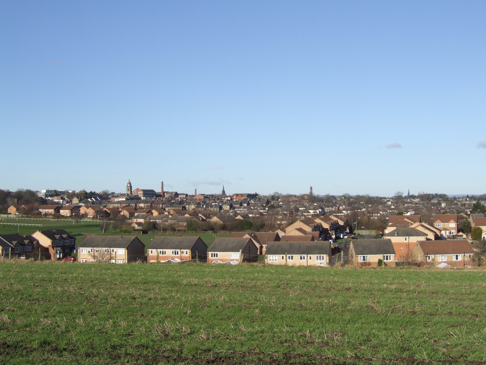
| Morley from Topcliffe Lane |
My map is old enough to be missing some of the housing developments from these parts and the right of way follows the edge of Bantam Grove Lane and Watering Meadow as I observe the sort of contemporary houses that I seem to forget exist, but there must be plenty of people living in them. Rejoin the country path as it follows the beck behind the houses before start the steep ascent out of the valley up to Topcliffe Lane. It's good to feel the heart pounding as I go as I know I'm getting a proper workout after my usual shuffling, and ascend only 25 metres or so but the top of the ridge offers a panoramic view over Morley with the Town Hall and its spires and factory chimneys prominent, and also a pretty good look towards Leeds too. It's a distinctive bit of high ground too, as Topcliffe farm is a fairly obvious sight from Leeds's high vantage points, and the lane follows to top of the ridge for a good way offering views and sharp wintry winds to complement the sunshine before I encounter a squadron of cycling ladies out on their day's tour. When Topcliffe Lane becomes an actual road again, it passes an embankment that is one of the few visible remnants of the GNR Ardsley - Laisterdyke branch, and we also have three substantial mill buildings (Topcliffe, Oak and Southfields) pleasingly all still in use for commercial purposes, unlike the sadly dilapidated Tingley Mills. Pop out at the A650, next to Saxon's Aquarium centre and cross over to follow the ginnel that squeezes between the houses to lead out to the A6029 and as this is followed south to meet the bridge over the M62, the familiar landscape features of Emley Moor Transmitter and Ossett Parish Church loom out with the Pennine hills beyond.
 |
| Soothill Tunnel |
Leave the road to walk a stretch alongside the motorway and see that party of cycling ladies following this route too, and the signs around here warn us thunderously that this is private land and that we are to stay on the footpaths come what may. It's all a matter of following the field boundary until you head south to meet and cross the upper reaches of Hey Beck, and wander on towards St Mary's Woodkirk, and then dodge the tethered horses as you arrive in the familiar surroundings of Woodkirk Sports Club. It looks like the remains of Woodkirk station are still intact as they were last April, and I'm not going to follow the Leeds Country Way path, instead I will wander down into the dank and muddy cutting to have a good trespass and take a look at the east portal of Soothill Tunnel. The tunnel is completely sealed off at this end, and it's wise to keep your distance as the signs warn of toxic gas accumulation within, caused by the landfill above, and all the websites that take an interest in dark places warn that this is one tunnel to not attempt to explore. Thankfully, there are concrete steps to take you up the steep side of the cutting, so it can be escaped with ease, and park myself by Quarry Lane to water, before following it north to take a peer over into Howley Park quarry, an aggregate working that dominates this area. Take the path that follows the southern boundary before descending to meet the path that goes between quarry and golf course, and the going down here is no fun at all as it's severely overgrown and I can only imagine it will be worse once spring has sprung. Emerge onto Howley Hall golf course and pause to study the map and pick my route until I'm made aware that I'm stood in the middle of the fairway and four guys are waiting to tee off, fifty yards to my right. I retreat to allow them to play on, before they try to convince me that the right of way doesn't actually cross the golf course. I ignore their directions but press on forward, avoiding other golfers to meet the access road and pass one of Morley Tunnel's massive ventilation shafts, and that must mean that I'm at one of the many perceived half-way points on this circuit.
 |
| The Bridge to Nowhere |
Emerge onto Scotchman Lane, and the right of way on the other side supposedly crosses the field at the diagonal but there's no trace of the path in amongst the furrows, so I pick my way around the boundary to meet the top right corner where the path does make an appearance and pause here to have lunch, despite the fact that the field reeks of old cabbage. Thence carry on to meet the edge of the M62 and wander up to meet on of those bridges to nowhere to link farm land on both sides of the motorway but is actually completely useless because of the angle of decline on the land around. It does carry the right of way and i follow it rather than have a continuing odyssey through the fields, and I go on up the field past a spooky old farm house to emerge onto Bruntcliffe Road next to Morley Victoria underground reservoir and across from St Andrew's church. Following the road isn't much fun, but this part of the world seem short of field paths so carry on to the crossing of the A643 and say hello to the Morley in Bloom stone to cross over the M621 to the corner of Gildersome Spur industrial estate and feel like I'm off on the LCW again. Take the turn head onto Nepshaw Lane, and meet that group of cycling ladies again, and I'm now convinced that they are trailing me! Caravans seems to be the tale of this road, with a Traveller's encampment at it's south end and a sales yard at the north, whilst the middle is a rather pot-holed track that shadows the M621 and has a dirt-biker pounding it's way up and down it. It also has too much discarded living room furniture and i wonder why someone might drive out here to dump it when Middleton tip isn't exactly on the moon in terms of distance? Emerge onto Asquith Avenue (named after the Prime Minister born in Morley!) and I'm sorely tempted to trespass again into Dean Wood to seek out the north portal of Gildersome tunnel, but decide against it as it's some distance away in unknown territory and there are more thunderously worded notices to warn away the would be trespasser. Discretion being the better part of valour, I go on to join the A62 for a much less exciting walk northwards, but Gelderd Road does at least offer the best views towards Leeds of any of that city's major arteries.
 |
| Leeds from Broad Oaks Lane |
On to Rooms Lane to enjoy a return to proper country walking, and the sight of a bridge parapet at the roadside must mean that we are at the site of Gildersome Station on the L&NWR's New Leeds Line, hidden away in the middle of nowhere. The path down to New Stables seems under-tended, and the farmstead itself seems to discourage walkers passing as the stile has wire mesh above it, but this can be removed easily so maybe it's must to keep wildlife in? Meet the scene of part of 2011's nocturnal ramble as I walk up to the edge of the M621 again, and pass through the underpass to emerge on the edge of Churwell where the local action group seem to have set about creating an urban wildlife idyll with wild flower and butterfly gardens, wetlands and dipping ponds by the beck, and a bug house and many birdfeeders. A place to loiter on a warmer day than this, and I carry on to follow the footpath that leads between the houses to the A643 at the point that it stops being Elland Road. Cross over to the farm track that leads to Broad Oaks farm, and the signs indicate that you cannot drive to Harder Brothers down here, and you assume that some sat-navs must have sent lorries down a dead end this way in the past. The low sun and cloud offers a silhouette of Morley's towers to the south, and north we get the best view of Leeds as the breaks in the cloud cause all the buildings of the city centre to glow appreciably, and that's two more excellent viewpoints discovered on my travels. Carry on to the bottom of Daisy Hill and follow the rising path at the beckside to emerge onto the road that leads down to New Bank Street and I wonder how I've never managed to get out here in the years I've lived here, so this presents another new perspective of Morley. Then meet the path that skirts some more new build houses to arrive with a good view above the railway station, a good place to go next time they send a steam railtour this way, and then it's down to stand by the station sign again to check my time and it's 2.45pm, just over 4 and a half hours to do the circuit and I doubt winter will offer many days better than this one, but we can be hopeful! and So that's 2013's season underway, and next weekend the serious business starts.
Next on the slate: Ingleborough!
1,000 Miles Cumulative Total: 475.6 miles
(2013 total: 10.3 miles)


No comments:
Post a Comment