The abiding image I have in my mind of walking the Pennine Way comes from my distant childhood and an episode of 'Go With Noakes' in which John Noakes took on the path in foul weather and extremely muddy conditions whilst wearing quite the most hilarious pair of 1970s flares. I recall thinking 'That looks no fun at all' and that impression still hasn't changed in 30+ years, as the Pennine Way resides somewhere near the bottom of my list of walking priorities, but the truth is that it is a trail that ultimately remains unavoidable when walking in the North Country. Indeed in all of my walking exploits since 2002, I have walked nine different sections of it, ranging from a few hundred metres to several miles between Stoodley Pike in the south and Hadrian's Wall in the north, so let's meet up with the FOSCL group and have day 10 on this trail and my longest single excursion on it to boot, and maybe I should start tagging my walks with
'Not Walking the Pennine Way'.
Hawes to Horton-in-Ribblesdale: 14 miles
 |
| Hawes & Wensleydale |
There were so many ways the trip out at the start of the day could have gone wrong, but the train is alighted at Garsdale and 15 walkers board the 16 seat minibus to ride out to Hawes, where a dozen of us can form the FOSCL party, led by Steve and John, and the trail can be embarked upon at 11am (a mere three hours after leaving home). My immediate feeling is that this is going to be a good day as I'll be on all new territory for the whole trip, departing the Market place in Hawes and turning up the hidden passageway that leads up to the Parish church and into the fields beyond, as I take up my place at the back of the group and go through the business of reintroducing myself as few of the regulars seem to remember my face. Good feelings dissipate as the rain comes at a fierce hiss and this is what I was expecting for a day of sunshine and showers, and it goes on as we pass through the village of Gayle and strike into the fields for some soft going. Taking a look back as we rise gives us look back into Wensleydale and it is clear that the rain isn't going to last and there's a lot of good looking skies beyond as the wind blows from the north as we go south, and as we ascend along Gaudy Lane the view back into Wensleydale's amphitheatre is a pretty good one with Great Shunner Fell and Lovely Seat rising high to the north and so much unexplored territory viewable to the west and east, and Hawes is already laid out in the distance, looking like a model village.
 |
| Snaizeholme & West Cam Road |
Leaving the track in favour of rough pasture, the Pennine Way offers a view into Sleddale to the south east, easily identifiable with Beggarmans Road ascending on the opposite side of the valley, and we suffer early heating problem as we ascend the slope of the long finger of high land which makes up the Dodd Fell ridge, with a cold wind outside and a lot of heat coming from the well-stoked internal furnace. The early going is hard work, going uphill is always tough early in the day, and once Gaudy house and civilisation is left behind the first break is made at the edge of Rottingstone Hill as the path evens out, crossing onto rough limestone moor land for the plough uphill to pass around the lump of Ten End, which had looked like the top of the ridge from below, but is merely a subsidiary summit of Dodd Fell. Rising further the sun blazes out and Sleddale recedes from view whilst to the west a much more impressive vista opens out, as far below us is the long blind valley of Snaizeholme with is farmsteads and plantations. A quick study of the map will show that we have ascended 300 metres since starting out, and you can see that you are now in the high country as the tops of Ingleborough, Whernside and Wild Boar Fell become apparent from behind the nearer hills. Meet West Cam Road and the rough track gives us a slightly firmer path to tread and we are assured that lunchtime is not too far away and we press on to find a wall to take shelter behind, and just as well as a fierce hailstorm accompanies pizza time.
 |
Whernside & Great Coum
from Dodd Fell |
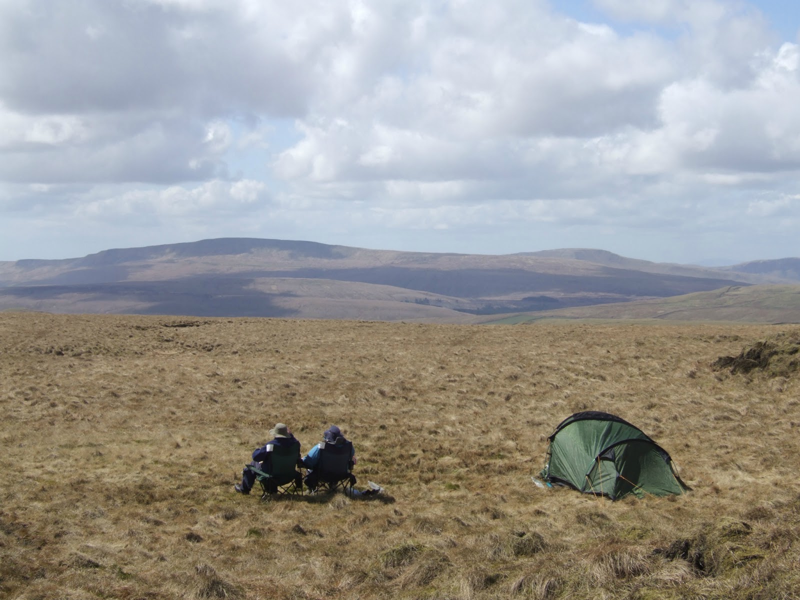
Thankfully, that's the last of the showers that we will be seeing for the day, and shortly the Pennine Way path is ditched to strike out to the top of Dodd Fell hill itself, that's another 100 metres or so of up hill over a lot of tussocky grass and around a number of shake holes and you spend a lot of time watching your footing and following the person ahead of you as the going isn't the easiest. The hill itself isn't really one to warm the spirits, a rather dull and undistinctive lump that offers no real profile or romance, but its location among the high hills makes for an excellent viewpoint, and if you are prepared to trace the somewhat indistinct trod up to the plateau and to traverse the peat bog which resides at the top a grand panorama can be taken in from the 668m trig point. Along with the the aforementioned hills, you get looks to the Eastern Lakeland fells and the Howgills, the North Pennines and Cross Fell, Great Whernside and Buckden Pike (still displaying snow remnants) and the tops of Pen-y-ghent and the exceptionally distant Pendle Hill off to the south. A great place for a pause with a view and a lot of solitude, and it seem that there are two guys camping up here, surely certain that they would be complete undisturbed for the day! Views absorbed, the long descent back to the track begins and the path down is even harder to trace than the one going up and because of my camera having issues again, I almost get detached from the group and have to go at the hurry-up, which means a lot more stumbling and descending rough grass sideways which cause some uncomfortable hot spots on my feet, but the group is caught as we find ourselves above a line of shake holes which have to be circumvented before rejoining the road, and it's here we find our remnants of snow, still persisting a month after winter passed.
 |
| Ingleborough & Cam High Road |
Back on the Pennine Way, we press on and almost feel the need to shed layers as the lump of Dodd Fell shelters us from the wind for a while as we move to Kidhow Gate, one of the remotest road junctions in the county, where Cam High Road is met and a group seem to have set up caravanning. Cam High Road is properly ancient, a Roman build to allow the legion to march from Wensleydale to Ribblesdale, and it makes for straightforward progress for us, and I can take a look down into Langstrothdale and start to pick out the Dales Way route that I should be walking next weekend and this bit of remote landscape can be made to feel that bit less intimidating. Just before the turn for Cam Houses Farm, we detour from the path again, to take in another summit, of sorts, and it's a stretch through the rough grass to the broken cairn at top of Cam Fell, which stands a modest 586 metres as a southern buttress of the Dodd Fell ridge, but offers improved views of the Three Peaks (with the Ingleborough massif looking particularly impressive) and as we can look from here down into the watersheds of the Ribble, Ure and Wharfe, we must be crossing the English watershed again. Return sharply down hill to the road again, and pass the cairn which marks the meeting point of the Dales way, and look into the huge plantation of Cam Pasture and plans to extensively harvest the trees is bringing the threat of resurfacing and heavy lorries on the High Road, and that is something which should be prevented at all costs. Plodding down hill takes a while to get to the path junction at Cam End, and a pause is taken to note that a sign indicates the closure of the path at Gearstones, but just how closed it is becomes a matter for some debate, and it looks like we'll have to find out next weekend, as I won't be the only one of this party coming this way, but surely the 12+ mile detour suggested must be some sort of joke.
 |
Limestone escarpments
& Pen-y-ghent |
South we turn as the Pennine Way descends into the large morass of hillocks which resides to the southeast of Ribblehead, and the path rises and falls to offer views back towards the viaduct and the high hills appear and disappear as we go. After seeing Horton quarry in the distance, it feels like we are on the homeward stretch, but there's still two more hours of walking to go, and the path threatens to get boring before we arrive at Ling Gill beck where we can pause to water and bask in the afternoon sunshine. The path leads alongside the nature reserve where the beck falls into deep cleft in the limestone, frustratingly obscured by trees, but it's still possible to see where immense slabs of stone have been undercut and scattered like so many playing cards, and that should remind you of the awesome power of the machinery of nature. Continue, getting used to the idea of striding the path back to Horton, when we are suddenly diverted off the track and uphill very sharply as Steve wants everyone to see the view from the trig point at Cave Hill, only 374 metres up high. but offering another excellent prospect of the Three Peaks, and as our third summit of the day we can claim this as our own Yorkshire Three (minor) Peaks! Back to the trail again at Brow Gill Beck, and shortly Old Ing farm mars our return to cultivated land after a very long time on the high lands. Again we detour from the Pennine Way, as the Ribble way path apparently offers better views, and that is certainly true as we walk below the long limestone escarpment which is illuminated in the best kind of afternoon sunshine.
 |
| Horton-in-Ribblesdale |
Traverse a completely unexpected deep cleft of a very small beck and then it's onward for a solid mile and there's a lot of talk about sheep, which everyone seems to have taken an interest in after that blast of winter weather, and I chat with John as he notes my unrelenting photography, and we talk walking exploits and he's a very genial chap, and much slower when he isn't leading, like he did on my first FOSCL walk (he's a fell runner by nature, and therefore mental). Pick up the pace a bit to meet the Pennine way again by the ruined barn above the dry valley and water sink of Sell Gill Beck, and the long descent down to Horton starts down a rock strewn path which really isn't the sort of surface that you want to be hitting at this late juncture. All sorts of ominous clouds gather and rain seems to pound down on Whernside, but we remain dry as Pen-y-ghent finally shows its familiar profile and the last footfalls are made to arrive in the yard of the Crown Inn, and after struggling through the throng at the bar to get my hard-earned pint of lager, a time check is necessary to see that it is 5pm and I'm encouraged that next week's walk should land alright between bus and train. It would be easy to sit and bask again as the sun returns, but it's to the station we have to head, and it seems Horton-in-Ribblesdale is busy because today was the Three Peaks race meeting, and the idea of that fills me with horror. Running it? Just the idea of walking it makes me feel giddy! So let's put that onto the list of 'deeply improbables' next to the complete Pennine Way, and start the long journey homeward.
Next on the Slate: The Dales Way, leg 3.
1,000 Miles Cumulative Total: 593.4 miles
(2013 total: 128.1 miles)


No comments:
Post a Comment