The Windermere Three Peaks: Brant Fell, School Knott & Orrest Head. 7.3 miles
Depart Fellside cottage at 1.40pm, in my shirtsleeves and carrying my new lightweight bag, setting off down Kendal Road for my first target of the afternoon, Brant Fell, which isn't very far behind our holiday house but getting to it is a bit of a circuit, having to wander up a cul-de-sac and take the well-hidden path up a very sharp rise up through the trees to meet the National Trust's viewpoint at Post Knott. This is a popular spot for those who want a view of Windermere, but don't want to walk too far, and it's a good view, but a bit lacking when you know that there's a higher viewpoint in the field behind it, privately owned but with permissive access, but I can't see the line of cairns that it asks you to follow, so a bee-line is made straight up the soft turf, avoiding the sheep and pick a way through the rocks to reach the summit. It might be on 191 metres high, but the view over the southern half of the lake is excellent, as is the look towards Latterbarrow on the opposite side, with Belle Isle below us. Sadly the mountain view is not quite so good, with the Coniston group shrouded in cloud and the Cenrtal and Eastern fells hiding in a lot of haze, despite the warm weather, and the view east demonstrates a lot of indistinct rough land. So the next viewpoint will have to be sought, but before I move on though I can ponder that whilst Wainwright claims that no trace remains of the summerhouse which once stood here, I'd love to know the purpose of the hooks embedded in the rocks and the origin of the mysteriously placed gateposts.
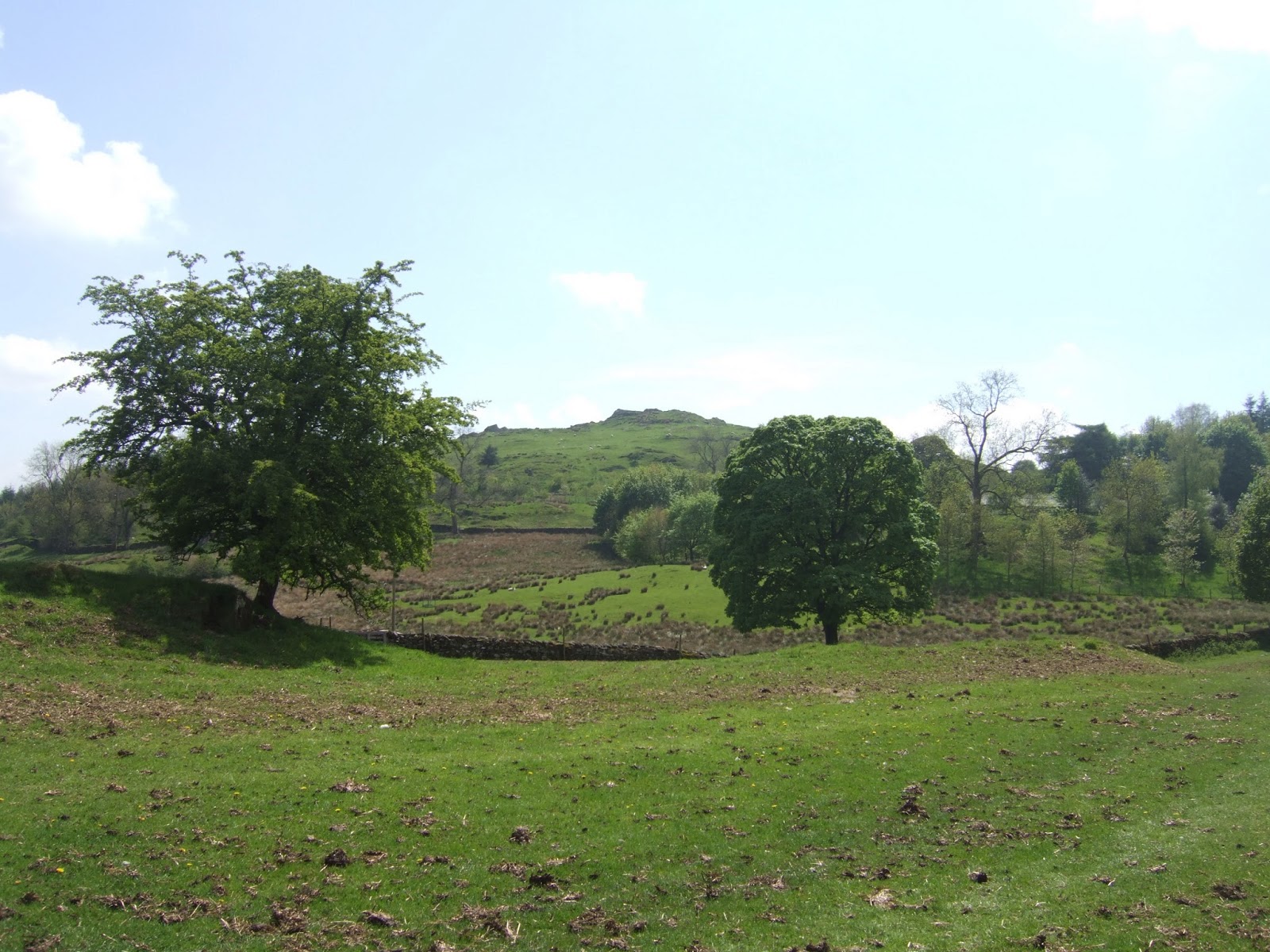 |
| Brant Fell... |
 |
| & the View South |
The trail is then struck from the north side of Brant Fell to make towards the farm of the same name, and finally find the guide cairns before a bit of path swapping is necessary before descending to meet the Dales Way's run in to Bowness and I try to not spoil the views from there, whilst also making mental notes, for later. Quickly strike off to the north-east through some rather well-manicured grounds which feel like a former estate that lacks an obvious house, and heading past the appreciably 17th century Helm Farm, before the path rises to travel around the rather more contemporary Windermere Park housing estate, before a rather confusing path junction takes us around the development at Low Lickbarrow farm. I can only hope that I'm going the right way to School Knott as I haven't had sight of it since leaving Brant Fell, and a trail is made along Lickbarrow Road and across the rough fields around Pinethwaite farm to ascend and meet another section of the Dales Way. Follow that stretch as it rises for a while before the path runs into the lea between School Knott and its companion Grandsire, and just before the path swings north up the hill, you find the secluded beauty spot of School Knott Tarn, an ideal place for an impromptu dip, if I was feeling so moved. The trod to the top of School Knott's 232 metres is obvious and straightforward, and the view is another goody, with the Far Eastern Fells being much more identifiable from here, with High Street prominent and the definition of the fells to the northwest improves but having not prior exposure to this region means I cannot identify their profiles at all.
 |
| School Knott... |
 |
| & the View West |
There's a sharp wind blowing over the top here so I don't linger long, and the descending path is just a easy to trace as the one going up, and the trod leads down all the way to the Droomer housing estate, which is bit confusing when it arrives more quickly than I'd expected, and it seems that the locals have preferred to regularly use the shortest distance to the top rather then the actual right of way. A bridleway leads through the estate to drop me out by the rather over-tended gardens at Gil farm, and the footpath rises around their fence to the foot crossing on the railway into Windermere, but there's not much risk of being mown down on this single track line. Having lost sight of my target of Orrest Head a while ago, you get a much better view of the higher and inaccessible Banner Rigg as I strike out along the farm tracks through a trio of fields which leads me past many quizzical looking sheep before arriving at the A591 where care and patience is needed to make a crossing without being caught by traffic. A short trot up the minor road leads me to the permissive path into Common Wood to take the back way up to Orrest Head, but a path junction that I hadn't expected to find leads me to take the wrong fork and my rise up through the wood ends up being a lot longer than it was meant to be, but the path that leads to the track to the 238 metre top of Orrest Head cannot be missed and one last rough ascent leads us to the view which made Wainwright love the lakes. This is indeed a spot to linger and absorb, as the view indicator offers identifying markers which help me pick out fells such as Crinkle Crags (really obvious), the Langdale pikes and the bulk of Red Screes, and I'd happily feed and water up here for a while as I watched the steamer make its way up to Ambleside, below its hill Wansfell.
 |
| Orrest Head... |
 |
| & the View North |
Unfortunately for me, I've got dinner duty tonight and I'd better get a move on as I've only got 40 minutes to get back to base to put the roast on, so I take the less favoured path off the summit avoiding the many folk coming up the other way, and hit the descent through Elleray wood, and resisting the urge to try to short cut down one of the many terraced paths that would surely get me lost, so meet the path above the high wall that leads you down through what feel like remote woodland before suddenly dropping you out on the main Road by the Windermere Hotel and the railway station, both of which arrived here before the town did. Hit the speed as I make off down Main Road, as the many tourists enjoy the many cafes on this gorgeous afternoon, and do I ever envy them as I hurry along. Then the A5074 runs through the many guest houses in the leafier lanes which separate Windermere town from Bowness, and Lake Road proves to be much longer and leafier than I'd thought it to be. Hitting the main shopping drag in Bowness kills my pace as the tourist throng just cannot be hurried through even when descending, and I have to resist temptation to go down to the lakefront as I'll have to reserve that for my Dales Way completion, so the rise up Kendal Road is followed instead and just as I think that it's going to be long ascent home, the Post Knott cul-de-sac appears and I find that Bowness is not as big as I'd thought. Roll up at 4.45pm, only a quarter hour late, and it turns out that I needn't have worried about preparing dinner as the cookery course (at Lucy Cooks in Staveley) has provided sufficient Fried Chicken for dinner tonight, tubs of baconated popcorn (!) to last the week, and enough carrot cake to last a lifetime.
1,000 Miles Cumulative Total: 631.2 miles
(2013 total: 165.9 miles)
No comments:
Post a Comment