An important thing to do when walking is to trust your map and to hold the idea that what the page states is where you should be going. The map is your friend and your helpful guide and you must believe in it and what it tells you, but sometimes it is wrong and will lead you astray, lead you into potentially dangerous places and you will wonder why the map misled you. Then you will realise that the map has one major limitation, it is only as good as the person reading it and the flaw is not with the map, it is with the interpretation of it, and you led yourself into peril and can be the only one to blame for your actions. If you are wondering how this relates to river and canal walking, read on...
Mirfield to Sowerby Bridge, via the Calder & Hebble Navigation path. 12.9 miles.
 |
| Battyeford Cut |
Have I ever mentioned that Mirfield station has a comically ridiculous arrangement of platforms? Well, I have now, and I depart it in shirtsleeves weather at 9.15am and over Ledgard Bridge and under the railway to seek the river path by Mirfield weir, and I'm sure there should be a way in front of the re-used mill to the riverside but I'm not about to wander through the front yard of a motor garage to find out. Around it we go to meet the riverside and along here there's evidence of an old cobbled path so you feel like you should be walking along here despite the absence of a right of way. This leads us under the abutments of the river bridge of the New Leeds Line, with a nice view of the apparently undemolishable remnants of Battyeford Viaduct on the north bank. Soon enough run up on Battyeford lock and the start of the next cut, this too has a marina and boatyard, and it's pretty big too, maybe it has cheap moorings? Carry on along through general leafiness and meet the flood lock at the end of the cut and cross over the Calder on the Battyeford Hauling bridge and the next river path is good too, wide enough for fisherman and their wheelbarrows full of gear to navigate, and under the railway line to Brighouse we go, a pair of bridges in stone arched and iron girder, and the older one is the one still in use, which must tell you something about the nature of permanence. Depart this district of sewage farms to join the Cooper Bridge cut, featuring one of the most desirable canalside residences and two very lost horse riders. Wander to the end of the cut and the flood lock, but there's no way to continue on the north bank of the Calder, so we have to double back to the A62 to cross Cooper Bridge itself and take a moment to look south to the start of the Huddersfield canals, where we will be venturing in no time at all.
 |
| Cooper Bridge Cut |
There's a very nice mill conversion here, but the way down to the riverside is vague and hard to find, we have to wander through the mill's car park until a wall has to be clambered over and the path feels like it might just be a stretch of unclaimed land between the water and the fences surrounding some industrial units. It's walkable, after a fashion, but it's only a metre wide in places and after the fields open up, you do start to wonder if the farmer out mowing his meadow would object to you joining him on some slightly firmer land. Persevere with that, despite taking a lashing of nettles and brambles again, passing under the Brighouse Line again, another stone arch / iron girder pair, and arrive at Kirklees lock with a feeling of relief that the worst of the going is probably over and that it looks like there is supposed to a path alongside the riverside that I walked. Press on along the Kirklees cut after a pause for watering, spotting the Grand Central train heading south and noting guide wheels by the locks, the ones that are entertainingly too short to accommodate 60ft barges. Also pass under the M62, and this is the largest motorway bridge so far encountered as it sweeps over the Calder valley high above us. Another flood lock and the end of the last cut of the Navigation, and at the next point it leaves the river at Brighouse, it effectively becomes a canal.
 |
| Blakeborough's Bridge |
Getting to that point turns out to be the hardest part of the day, the path goes along the inappropriately named Sunnyside, and then leads along onto the flood retaining embankment, complete with roving horse. It then appears to descend down to a narrow strip of land between river and industrial units, and the map seems to corroborate this, but as you go the path ceases to be obvious and you find you have wandered into a mess of brambles and unyielding riverside plants. If a path exists down here, it's clear that no one has cared about it in a long time, and you hit the thought that is it going to be easier to press on or turn back? I go on, as at the end of the buildings, Blakeborough's Bridge can be seen as an escape route and I can haul myself up onto a wall to walk a stretch clearly. That doesn't last long though, and to get to the bridge I have to fight through brambles, using by rucksack to tamp down the vegetation and stumbling many times as the ground seem to disappear from under my feet. A lad fishing on the other side of the river observes me going through all this wearing a look that says 'What is up with that guy?' There's no actual way up to the bridge from the riverside, but there is a pile of bricks conveniently arranged to give a leg up so I can clamber up the abutment, clearly some else has come down here and had the same problem as me. Feel huge relief after escaping that, and for those reading this as a guide, I say 'Despite what Explorer 288 and Google Maps say, walk down River Street because
the riverside path does not exist!' Over Blakeborough's bridge and fight more bramble to get the path on the north bank, and carry on along the embankment for as far as I can before industry takes the riverbank, but an industrial unit has left its gate open so I can escape to Armytage Road, clearly getting lost on Brighouse's riverbank is a kind of sport around here.
 |
| Brookfoot Lock |
Brighouse Marina is an oasis of sanity after that ordeal, and I investigate the pair of locks and roving bridge, and the New Mill Mill redevelopment (so good they named it twice), and carry on behind Sainsbury's to observe those buildings that could be flour silos or rope works and feel like I could use a pint in the bridge, but press on and soon enough the many mills in various states of repair have passed and it's out into the countryside again. Ganny Lock is one of the most attractive I've seen on the canal and the following path describes a broad curve on a strip between canal and river with run offs aplenty. Unappealing industrial units blight the landscape before the mill, lock and Grand Designs possibility cottage at Brookfoot, and there seems to be a walking party taking lunch here, so I press on to Cromwell lock to have my pizza, and to take a break to massage my bruised shins. Carry on between nature reserve and boating lake at Freeman's cut and the long stretch through the woods leads us all the way down to Elland, which has a spectacular mill conversion and an entertaining stretch down beneath the railway (again) and the A629, but both the pubs I pass are on the wrong side of the canal. Elland Wharf interrupts the path, and a detour has to be taken to cross Elland bridge to regain the path on the north bank, and it's nice to see a bit of Elland, to find that it is more than just a town named after a road.
 |
| Salterhebble Guillotine Lock |
The remnants of Woodside Mill look more like some eccentric folly by the canalside, and the railway is met again at Long Lees lock, oddly the viaduct seems to un-named, but a milestone tells me 'Fall Ing 19 miles' so we've come a long way over these last two walks! Pound on to Stainland Bridge and under the horse tunnel, to pop out by Salterhebble Guillotine lock, and I don't loiter to see how that operates, I press on as the day feel like it's going to turn and after a lot of level walking the pair of top locks above Salterhebble marina feels like an unwelcome bit of ascent. Ignore the branch toward Halifax and carry on towards Copley, and the family walkers are out here, as is a canoeist paddling his way up and down the pound at unreasonable speed. Passing under Copley Viaduct is a reason for joy, I've observed it so many times from the train up Calderdale, with its skewed arches at either end over canal and river, and plain arches in between, all told its one of my personal favourites! Onward into the last stretch to meet charity walkers doing a round trip from Brighouse on their return leg and I'm happy to crash them a quid, and to notice that Hollas Lane has an outsize bridge on the Calder and looks like a bit much for a road that doesn't go anywhere. The last three bridges come in short order and first sight of Calderdale's wonderful multiple-floor houses means the town is near and the Navigation Inn indicates the way to Sowerby Bridge wharf and the end of the Calder and Hebble Navigation.
 |
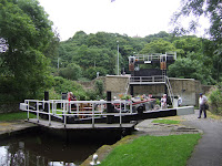
| Tuel Lane Lock |
I don't venture into the wharf itself, tourist trap that it is, but it does look like is has been developed with the greatest care and surely has a point or two worthy of exploring in the future, it always makes me happy to see industrial units put to good use. I've still got another mile to walk, the first of the Rochdale Canal, opened in 1804 as the first trans-Pennine canal, and closed in 1952 before being re-opened in it's entirety in 2002, and beyond the first pair of locks and across Wharf Street we come to the proudest monument to the restoration. Tuel Lane lock replaced locks 3 and 4 which had been infilled and with a fall of 20ft, it is the deepest lock on the inland waterways. It is also one of the few to be professionally operated and I'm privileged enough to find a boat descending the lock and watching the whole machinery in operation is really kinda awesome, Tuel Lane lock is immediately one of my favourite things ever. Then it's onward to find the point along Hollins Mill Lane where I joined the towpath for my walk to Mytholmroyd back in May, and just before departing I get some more Heron action to photograph. 3.10pm and not really enough time to water at any of Sowerby Bridge's holes, so retreat to the railway station, to wait for a hugely delayed train, so I could have gotten the beer in without difficulty after all.
1,000 Miles Cumulative Total: 322.2 miles


No comments:
Post a Comment